It's Really Happening

  • Travel
    • Roadtrip 2012
    • Australia
    • Asia
  • Food
  • Videos
  • About Kristen & Loren
uluru-sunset.jpg

A Day in Australia's Sacred Center

April 17, 2014 by Kristen in Australia, DTour, Outdoors, Places, Travel

I didn’t need to take off my shoes to enter these temples, though I did cover my head with a scarf to avoid the unforgiving summertime sun. “We’re going to power through the first kilometer,” warned our guide, brushing his horseshoe mustache before adding, “See you in the shade.” Ten minutes later, our group congregated at a platform overlooking a curved opening not unlike a cathedral’s apse, the walls painted with a waterfall that quietly dripped into the pool at its base. We were in the shadow of one of nature’s most grandiose creations.

loren-at-uluru.jpg

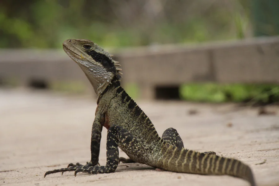
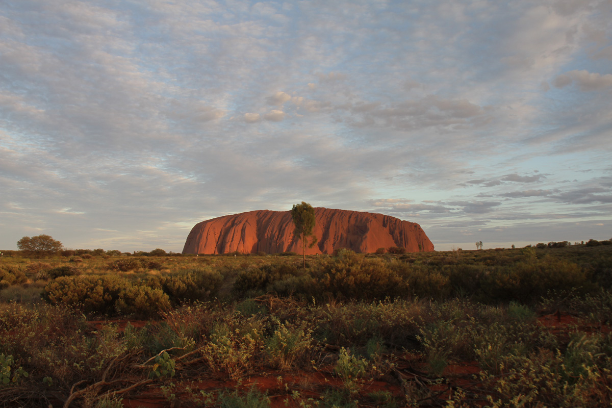
The famous red monolith in the middle of Australia, known as Uluru, Ayers Rock, or simply “The Rock,” is the kind of ethereal place that people travel the world over to see. A stunning beauty, Uluru is a photographer’s dream, slicing unabashedly out of the otherwise flat desert landscape. It has become a symbol of the Australian Outback, representative of the land of dingoes (some of which eat babies), kangaroos, and ultra-venomous snakes. In short, we couldn’t miss this place.

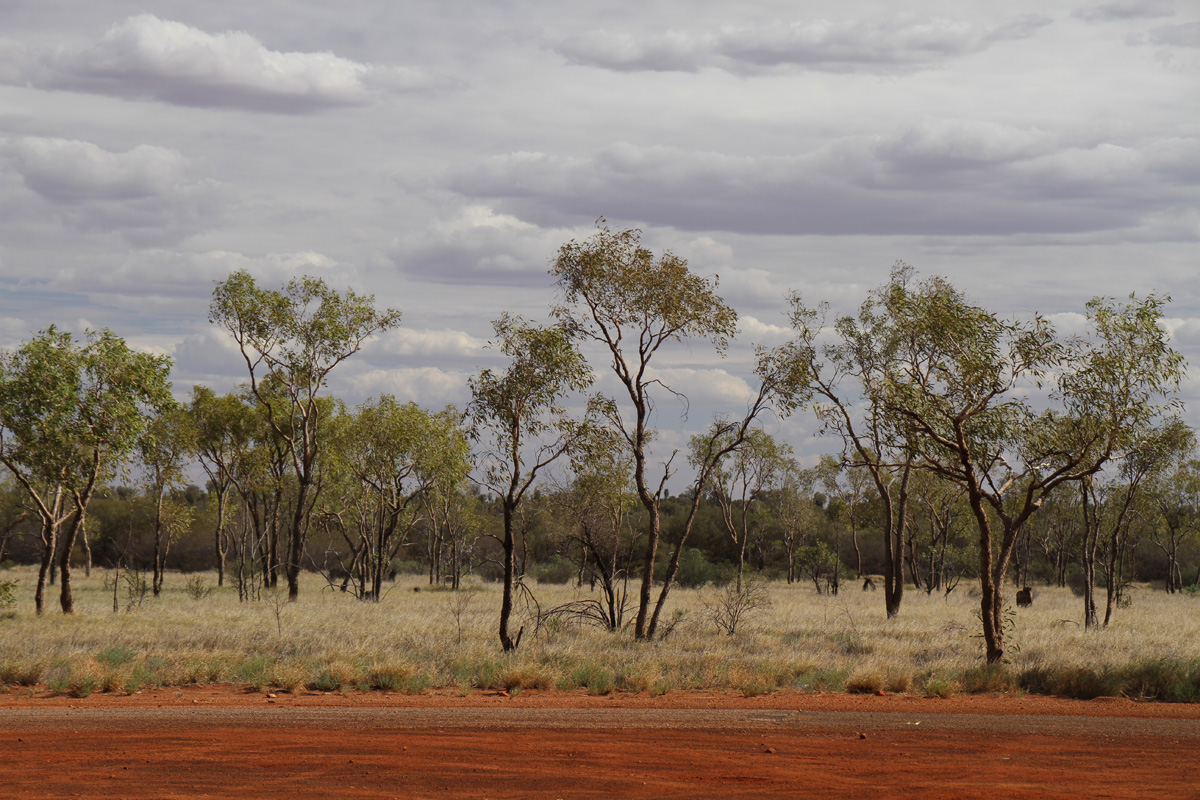
Five hours seemed a meager pilgrimage, considering the trip from Alice Springs to the remote Uluru-Kata Tjuta National Park took 3 days before the highways were built. We set out with Emu Run Tours on a bus with about 30 other eager tourists and two tireless guides, Tick and Mark.

emu-run-tours-uluru-guide.jpg

“Over to your right, we’re coming up on a rare sight,” Tick remarked about 3 hours into the drive. The entire bus perked up, prepared for a glimpse. Tick and Mark had spent most of the journey teaching us about this vast territory and its humbling history. “If you look carefully, you’ll see an Australian Rubber Tree, with big black fruit hanging from its branches, distinguishable because it grows without foliage.” We rounded the bend and just then Tick burst into laughter. Rubber tires were strewn about a lone skeleton of a tree near the road. “Gotcha,” he said triumphantly. Cheeky Australians.

outback-australia.jpg

The park’s namesake behemoths, Uluru and Kata Tjuta, can be seen for miles in any direction, so it’s no wonder they became important meeting places for the Anangu, the group of aboriginal tribes who’ve lived here for over 30,000 years. Remarkably, the rocks also form the backbones of Anangu Creation Stories: in the absence of a written history, the natives use Uluru and Kata Tjuta as their physical records. Whereas organized religions have holy texts, the Anangu have these rocks. With their decipherable contours, the rocks are used as cues for recounting ancient stories that teach morals, social norms, cultural history, and even survival skills. Considering that the rocks are timeless, more permanent than any written words or man-made reminders of ancient stories, it’s a pretty ingenious system.

kata-tjuta-australia.jpg

Staring at the simple shape of Uluru from afar, you’d never guess that this chunk of rock continues underground for kilometers. In fact, what we can see above ground is really just the tip of the iceberg. If you were to follow its underground geologic path twenty-five kilometers to the west, you’d arrive at Uluru’s lesser-known but just-as-sacred cousin, Kata Tjuta. To this day, the Anangu still use Kata Tjuta for their age-old rituals and ceremonies, during which times it is closed off to the public. A conglomerate sedimentary formation of 36 domes, its name means “many heads,” and it was borne out of the same uplifting process as Uluru some 500 million years ago. Though it’s not as iconic from a distance, it’s breathtakingly beautiful up close.

kata-tjuta-hike-gorge.jpg

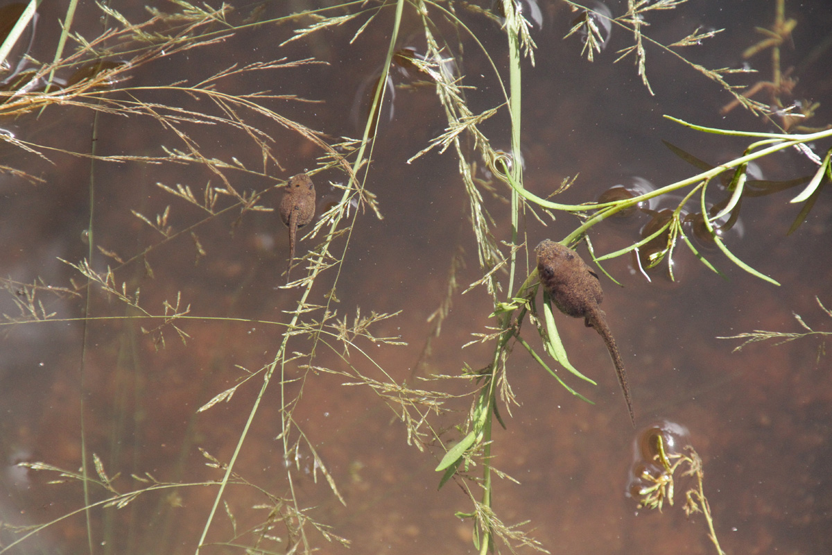
Red walls rose up on either side of me, plunging into the electric blue of the sky. The wind blew at my back, gently coaxing me deeper into Kata Tjuta’s Walpa Gorge. To my left, I could hear a stream that paralleled the path, hidden from view by bright green trees, bushes, and grasses, all guzzling from the stream’s lifeline of water. We took our time, stopping every few moments to snap photos, stare, and listen. Time slipped further away when we came upon a series of small ponds with tadpoles. They darted around just under the surface, seemingly oblivious to the fact that they were in a desert.

tadpoles-uluru.jpg

A faint horn sounded, jolting us out of our inquisitive daze. Was that our bus, sounding the final notice before pulling away? Sprinting the whole rest of the way back, we jumped on with smiles of exasperated relief plastered onto our faces, gasping for air. We weren’t even late; apparently the bus horn is a prank the guides pull on the last to board the bus. “Told you they’d be running!” Tick hooted as we took our seats.

Though some affectionately refer to it as such, Uluru is no ordinary rock. Even just saying the word feels like the start of a sacred chant: OOH-loo-roo. Its name has no translation, adding to its mystical allure, and its immense cultural significance really sets it apart from the average mountain. In the days leading up to my Uluru trip, I was sure that I’d want to climb the controversial path that leads to its summit. As a climber, I love to interact with rocks, experiencing them at close range, accepting their challenges. But after all that I’d learned about this sacred place, my mind had changed. The fact that these formations continue to play critical roles in the preservation of the world’s oldest surviving culture warrants, I think, some heavy respect.

uluru-climb-ayers-rock.jpg

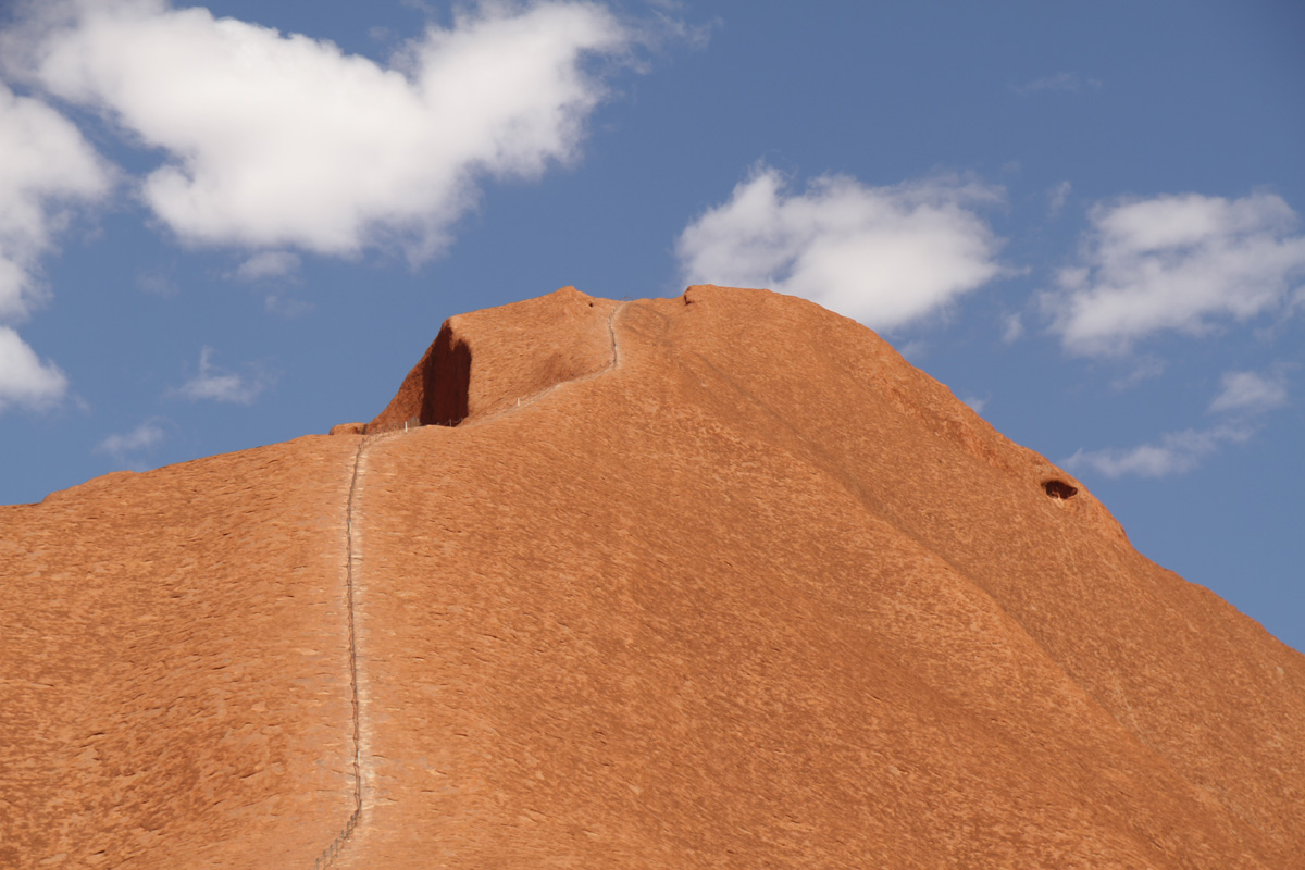
Fortunately, the decision was made for us that day, with the climb to the top closed off due to the sweltering February heat. Instead, we followed our guides around parts of Uluru’s base, peering at 17,000-year-old murals, gazing up at temporary waterfalls from the previous day’s rains, and entering alcoves so sacred that, out of respect, photography was prohibited. In the end, it didn’t feel like we’d missed out on anything.

emu-run-tours-uluru.jpg

With the sun loosening its grip on the day, temperatures dropped to a much more palatable 90 degrees for our final stop. Even amid the hordes of camera-wielding tourists that were arriving by the busload, it was a serene scene. We sipped on cool champagne and nibbled our picnic dinners as the sun began its spectacular light show. Uluru reflected every color on the spectrum between red and purple. As the sun lowered, features that resembled buttresses cast shadows in stripes across its length until eventually the sun dipped below the horizon, leaving in its wake fluorescent clouds that hovered to the west over the silhouette of Kata Tjuta.

uluru-sunset-crowd.jpg
photo-1.jpg

As I gazed out at the impressive figures before they disappeared into the dark, I slipped off my sandals and dug my feet into the warm red sand for one last chance to get closer to this place that is the heart of a continent, the soul of a civilization.

red-sand-feet-uluru.jpg
April 17, 2014 /Kristen
Alice Springs, Australia, desert, DTour, DTourist, hike, kata tjuta, nature, outback, outdoors, rock, sunset, tour, travel, uluru
Australia, DTour, Outdoors, Places, Travel

Video: Scenic Walk to Manly

February 15, 2014 by Loren in Australia, DTour, Outdoors, Travel, Videos

One of Sydney's most outdoorsy activities is the Scenic Walk to Manly, which is indeed scenic. So much so that we stopped every five minutes and the four-hour walk took us much longer than that. After getting fresh barramundi fish and chips overlooking the sea in Manly, we hopped aboard the ferry back to Sydney for another scenic view: the beautiful harbour.

February 15, 2014 /Loren
animals, Australia, DTour, hike, nature, Sydney
Australia, DTour, Outdoors, Travel, Videos
20140126-093928.jpg

Sydney's (Very) Scenic Walk to Manly

January 28, 2014 by Loren in Australia, Dining Out, DTour, Outdoors, Travel

It’s about the journey… not the destination.

Sure, you could take the ferry to Manly, a funky upscale surftown northeast of Sydney. Or, you could go at your own pace on the four-hour Manly Scenic Walkway (MSW). The first step for us was a bus ride about 30 minutes or so from city center, darting over the landmark Harbour Bridge with quick peeks at the tips of the famed Opera House and charming, hilly neighborhoods. At the second bridge, called the Spit, we hopped off (or, as they say here, “alighted” - new word for us) to let our feet do the rest of the job.

20140126-094039.jpg

The MSW is a 9.5km path that winds along the varied coastline of the middle and north harbour between Spit Bridge and its namesake peninsular suburb (stay tuned for jokes about manliness), cutting right through the Sydney Harbour National Park. The walk showcases some of the city's best outdoorsy assets, including beaches, forests, rock formations, a waterfall, and even some wild animals.

20140126-094120.jpg

Our walk began in lush tropical greenery, with large leaves encroaching on the path and small lizards eyeing us nervously as we brushed by. They seemed like a cross between iguanas and bearded dragons; we later found out they’re basically just that, called Eastern Water Dragons. With each sighting, the lizards got bigger and bigger. A sudden wave of fear washed over us. “Oh crap,” we thought, “We’re hiking in Australia, where everything can kill us.” But the anxiety soon subsided and we continued on, only slightly weary of impending doom from poisonous creatures.

20140126-095543.jpg

Happy families played at the beaches and friendly locals passed us on the trail with warm smiles and waves. Weaving in and out of coves, climbing up and down wooden steps, and catching spectacular views was the standard. During the final stretch, we even stole glimpses of a few kookaburras (iconic Australian birds), who called attention to themselves with their monkey-like cackling.

20140128-181259.jpg

Arriving in Manly brought on a change of scenery: hordes of tourists and locals (Manly men and women), most in swimsuits and flip-flops. Around town we saw a Manly Italian restaurant, Manly salon, and even a Manly pharmacy (their number-one seller is, I presume, testosterone). Wet-suited surfers were out catching waves and strutting their Manly-ness.

We were famished, so we bee-lined through the crowded esplanade and right into the first oceanside eatery serving fish and chips. The Fish Shack, with its chalkboard signage and hand-painted wall art, was proud to serve only sustainably-caught seafood, so we were immediately on-board. We opted for local Manly beers and the national specialty of barramundi - Kristen’s beer-battered and fried, mine grilled (perhaps not the Manly-est of choices). After a four-hour hike, it was exactly what we needed.

20140128-183239.jpg

The return ferry back to Sydney took much less time than our exhausting walk, but it was a perfect way to end the day. We sat lazily and shuttled past the same cliffs and coves that we had laboriously trekked through hours earlier, catching a much different perspective of the beautiful bay. Further on, our new and improved view of the Sydney Opera House was a welcome reward for a long day of hard work.

20140128-183201.jpg

Disclosure: I'm traveling on a #DTour in Australia on behalf of DoubleTree by Hilton, but it's totally cool because I still do and write about the things that interest me. Hope you enjoy it!

January 28, 2014 /Loren
Australia, DTour, DTourist, hike, Manly, nature, outdoor, Sydney
Australia, Dining Out, DTour, Outdoors, Travel
la-luz-trail-loren
la-luz-trail-loren

The Wild Side of Albuquerque

December 22, 2013 by Loren in North America, Outdoors, Places, Travel

When we at last reached Sandia's summit in the late afternoon, my tired body relished the crisp mountain air. I handed over my credit card in exchange for a pair of cheap one-way tickets. Outside on the wooden deck, we breathed in the enormous view and marveled at the Albuquerque grid stretching west before us. From way up here, we could almost pick out our tiny house (okay, my mom's house) far down below.

After having spent way too much of the hot summer indoors, Kristen and I decided that it was time to retackle the La Luz Trail, a not-too-strenuous trek to the top of the mountain we see everyday from our backyard. The eight-mile path winds its way up through four different climatic zones, ending at a panoramic intersection of east-facing ski lifts and a west-facing tram.

The first couple of sweaty miles offered us a fair share of prickly pear cacti, piñon trees, skittish lizards and chattering birds. My sandaled toes grew dusty as I squinted at the monument-like peaks surrounding us, searching for familiar vistas to orient myself. But the mountain, which changes colors throughout the day from city level, had taken on an unrecognizable form. It was even more spectacular up close.

The upper half of the hike is drastically different. You can expect to find colorful wildflowers, fragrant pines, and unusually large squirrels with tufted ears. And be prepared to flex those leg muscles. There are tons of switchbacks, cutting back and forth through dark forest and across a sunlit slope piled with jagged pink granite rocks.

High contrast: the lower half of the hike vs. the upper half

The sense of accomplishment I felt at the top, knowing that my legs alone carried me here, was immediately followed by a feeling of relief that all we had to do was hop on an electric-powered tram back down. Once the forty or so people boarded into the dangling box, it hung heavy for a moment before swooping into motion. It was surprisingly smooth. We floated down towards civilization, as if in a giant elevator, and savored our knee-saving descent. My only wish: to feel the breeze just outside the window.

sandia-tram-albuquerque
December 22, 2013 /Loren
albuquerque, hike, hiking, nature, new mexico
North America, Outdoors, Places, Travel
IMG_7822.jpg

Olympic National Park

September 04, 2012 by K & L in Cooking, Food, News, North America, Outdoors, Places, Roadtrip 2012

Even though it wasn’t initially in our plans for this trip, we’d heard great things about the Olympic Peninsula, a wild section of incredible rainforest, mountain and coastline in Northwest Washington. How could we miss out on that? We joined back up with 101, the first time since California, and soon realized that we’d hit the jackpot with weather: blue skies, warm sun - this isn’t the Olympic Peninsula we’d thought we’d encounter.

Blue hydrangeas

Blue hydrangeas

IMG_7722.jpg
IMG_7739.jpg

Without a clear plan of where we’d try to reach by nightfall, we started following the brown signs towards a Big Spruce tree, and were pleasantly surprised by the heavily wooded two-lane road lined with full-bloom blue hydrangeas that opened up to a small town strip and a magnificent lodge, at the edge of Quinault Lake. Practically entranced by the beautiful 1920s-era structure towering above us, we walked into the main lobby wide-eyed, snapping photos here and there, and made our way out to the back lawn which was dotted with Adirondack chairs looking out to the beautiful lake. If we’re ever looking to splurge on lodging, this seems like a perfect place. We glanced at a window sticker that proudly proclaimed the lodge had been rated as one of the “Best Places to Kiss in the Pacific Northwest”. Duly noted.

IMG_7741.jpg

Driving around the small town, we decided we’d already seen enough incredible trees, so we turned back to 101 and made our way to a scenic beach turnout. We left the car at the roadside and paid a visit to the amazing expanse of smooth-stone and driftwood beach, a small hike through the wooded buffer from the road.

Olympic shore stones

Olympic shore stones

Olympic shore driftwood

Olympic shore driftwood

Finally deciding that we needed to hurry up and get to a campground, we anxiously walked into a ranger station asking about the status of the camps in the park. Her worried look didn’t put our minds to ease, and we took her recommendation (which fortuitously jived with the recommendation we’d received from a friend) to get to the Hoh River Campground as soon as possible. From there, it was strictly business. We drove a few loops of the campground, noting that some of the spots amazingly boast river access, before claiming one of the few remaining sites.

Hoh Campground

Hoh Campground

We needed to get some cash in order to avoid grossly overpaying for our site, so we again got into the car, unknowingly needing to drive another 45 minutes before reaching the next grocery store and ATM. We were losing sunlight, but Kristen got her wish of touring Forks. That’s right, the same Forks from the Twilight books. We grabbed groceries at the same store Bella shopped at, we drove by the Forks Highschool (the wooden sign which was replicated for the movie), and we drove by “Bella’s” house, which wasn’t the same from the movie but still photo-worthy. Armed with cash, wine, SoCo, and a couple of food items, we made the trip back into the forest to our home camp.

Forks High School

Forks High School

Unfortunately we’d run out of sunlight, so we didn’t get the chance to do any hiking that night, but we did get to make a yummy dinner. We reheated our Pok Pok chicken wings over the fire while roasting foil-wrapped yams (purchased at the grocer in Redwoods Natl Park), in the fire. Once they were soft to the touch, we pulled the yams out and mashed them into a pot with half a can of coconut milk (from Trader Joe’s in Corvallis). The combination of sweet potato/yam with coconut milk is Loren’s signature dish, which has become a staple in our home, though this marked the first time we’d tried the fire-roasting technique. Worked perfectly.

Sweet potatoes roasting in foil

Sweet potatoes roasting in foil

Sweet potato mash

Sweet potato mash

After dinner, we put the rest of the can of coconut milk on the fire grate and let it heat up. Then, we added some hot coco mix (courtesy of the hotel in Sedona), and passed the hot can back and forth for a sweet, silky, warm dessert drink.

IMG_7820.jpg

The next morning, we were determined to get a hike out of the Hoh area, so we left our campsite on foot to do the mile and a half Nature trail, lamenting that we couldn’t do the 18.5 mile hike to the Blue Glacier on Mount Olympus (maybe next time...). But what we saw was enough to get us excited about the area. We learned about the different phases that the riparian rainforest ecosystem goes through, with winding riverbeds changing, literally paving the way for certain kinds of trees to initially thrive, which are then replaced by the towering Douglas firs and Western Hemlocks. It’s interesting to think about the different phases of growth that forests go through, which take decades upon decades to transpire. We as humans have such a warped sense of time; when we see forests of Ash and Cottonwood, they seem permanent, don’t they? But everything in nature is constantly changing, always.

IMG_7715.jpg
IMG_7823.jpg
IMG_7847.jpg
IMG_7845.jpg
Hoh River

Hoh River

As we left Olympic and drove through the northern peninsula town of Port Angeles (yes, also from Twilight) we realized we’d made our first big turn East, marking the end of the West-Coast portion of the trip.

September 04, 2012 /K & L
camping, coconut milk, Forks, hike, Olympic National Park, peninsula, rainforest, roadtrip, Twilight, Washington, yam
Cooking, Food, News, North America, Outdoors, Places, Roadtrip 2012
IMG_7679.jpg

Eugene, Corvallis, and Mary's Peak

September 01, 2012 by K & L in Cooking, Food, News, North America, Outdoors, Places, Roadtrip 2012

Eugene offered us two things we desperately needed: coffee and wifi, courtesy of a cafe called Perk. Afterwards, we drove around a few neighborhoods, and once we didn’t get that warm cozy feeling from the town, we made a snap decision to head north to a campground near Corvallis, rather than stick around and have dinner in Eugene. (Sorry, Eugene. We’ll give you another chance someday.)

We barely got to see Corvallis but what we saw, we really really liked. We paid a visit to Trader Joe’s to stock up for the night, before driving to the nearby Mary’s Peak, where we were by now confident that we’d find a camp spot. And we were right! We were the second group into the 6-spot, tents-only campground. We cooked some of Trader Joe’s pre-marinated tri-tip steak with some roasted veggies. Another campfire cuisine success, and we even had some steak leftover for breakfast!

Steak Dinner

Steak Dinner

Breakfast

Breakfast

Camping at Mary's Peak

Camping at Mary's Peak

Boy did we need a hot breakfast the next morning. It got pretty chilly that night, probably low 40s, and the steak and eggs certainly hit the spot. We chatted it up with the ranger who came around, and he recommended the views from the top of Mary’s Peak (the tallest peak in the Cascade range), which we’d already planned on doing before leaving, but about which we were now even more excited.

IMG_7674.jpg

Even though it wasn’t a totally clear morning, we were able to see the amazingness of Mount Hood and several other peaks. Apparently on a really clear day, you can see for about 500 miles. Other perks of the hike: it felt great to have a morning hike to get the blood flowing, and enjoy the warm sun at the top of the peak.

View from Mary's Peak, Oregon

View from Mary's Peak, Oregon

September 01, 2012 /K & L
camping, corvallis, eugene, food, hike, mary's peak, mountain, oregon, roadtrip
Cooking, Food, News, North America, Outdoors, Places, Roadtrip 2012
Crater Lake

Crater Lake

Welcome to Oregon

August 30, 2012 by K & L in Dining Out, Food, News, North America, Places, Roadtrip 2012

With the prospects of exploring a new state, we crossed our first state line in 15 days and were filled with excitement as we made it into Oregon. First up on our agenda was a stop at Crater Lake.

IMG_7601.jpg

The deep, rich blue colors that emanate out of Crater Lake seem otherworldly, and it’s pretty mind-boggling that the beautiful lake was born out of a catastrophic geological turn of events. What is now calm, placid lake water was once a mountaintop that exploded in a volcanic eruption, creating a caldera that is as deep as the sheer cliffs surrounding the lake are high. It’s America’s deepest lake, and it seems as though the underwater ecosystem remains rather mysterious even to this day, with few expeditions into the deep blue lake to chart the strange creatures at the bottom.

IMG_7623.jpg
IMG_7640.jpg
IMG_7638.jpg

We explored a few overlooks and hiked up to a few vistas, and it was beautiful. From one spot, there were so many grasshoppers out that it sounded like the tic-tic-tic-tic-trrrrrrrr of sprinklers. At another spot, neon chartreuse-colored moss balls clung to dead trees and rolled around on the ground, seemingly looking for another home. The tiny pinecones were also rather endearing. After a few different vantage points, we kept on trucking further into unknown territory, a city we've been planning to visit for a long time...

Bend, Oregon, is a charming little outdoorsy town that could definitely end up being a relocation destination. This part of Oregon is sheltered from the coastal rainy weather by the mountains, so it therefore enjoys better weather (which has been a drawback to a few of the places on our relocation list) than much of the state. It’s also very close to skiing (Mount Baker), and a couple of hours from Eugene and Portland. We stocked up at REI - Loren replacing some age-old khaki pants that were at least 3 sizes too big for him with some better camping pants which he may have found in the boy’s department (it’s not easy finding 28x28s or men’s XS).

While driving to the downtown area, we passed the cyclepub and kicked ourselves for not having the camera ready. It’s exactly as it sounds: a pub that’s on wheels, with patrons all facing in on each other pedaling to move the pub from one spot to the next. Drunk cyclists? not really - the contraption appeared to be commandered by a sober coxwain-type, facing forward at the back of the thing.

So we parked and mosied our way around the historic downtown parts, window shopping at a few closed stores (it was after normal business hours), before sitting down for dinner at a cute restaurant called Zydeco Cafe. True to Oregon style, this restaurant focuses on high-quality, organic, sustainable, local foods, and the food was a treat from our couple of nights in a row of campfire meals.

Bend, Oregon - Zydeco

Bend, Oregon - Zydeco

Loren’s dish was wild boar! Absolutely delicious. Kristen’s dish was a safe steak, which was also mouth-wateringly yummy. What made both dishes even more memorable was the roasted veggies side - butternut squash, green beans, peppers, and pearl onions - we couldn’t have done it better!

We drove through a couple of sleepy neighborhoods after dinner, even though it was dark, which confirmed our suspicion that we could see ourselves living in this quaint town. Then we headed for the hills, where we found a campsite at a National Wilderness area. We set everything up in the dark and quickly retreated to our sleeping bags.

Camping outside of Bend

Camping outside of Bend

August 30, 2012 /K & L
bend, camping, crater lake, hike, national park, oregon, roadtrip
Dining Out, Food, News, North America, Places, Roadtrip 2012

Life's really happening, so we’re doing our best to live it to the fullest by traveling near and far, eating good food, and connecting with people along the way. Follow us as we chronicle our adventures around the globe and make the most of this wild ride. 

Penny and June. ❤️ @pnlpklein @juniperklein
BLACK LIVES MATTER
Family meal on the back patio with grilled wild caught salmon and shishito peppers. #onthetable #denver #vscocam
Family time on Coronado Island last weekend 👨‍👩‍👧🏰😎 (📷: @marchelle_thomson) #takemeback
Spent two and a half days in the mountains on a staff retreat with my coworkers, who happen to be eleven of the kindest, most passionate, most inspiring people I've ever known 🙌 #goteam #alliance #sustainablecolorado
HUGE thanks to my super generous cousin who showed us an amazing time in Steamboat, and hooked us up with this beautiful ranch house for my birthday. It was out of cell range, covered in fresh snow, and filled with family. Just what I wanted 🏂❄️💖 #

Travel | Food | Videos | About
Roadtrip 2012 | We Went to Asia | DTour Australia